Short Answer
In a dim reading room at the American Historical Association, a group of scholars once hunched over an old map, trying to identify its origin and purpose. After a long silence, one stood up and repeated a refrain he often told students: “No map can answer all the questions it raises.” That moment, captured in a 1995 issue of Perspectives, captures the enduring fascination and challenge of cartographic sources. Maps are among the oldest forms of human communication—perhaps even older than written language. Every culture across the globe has made and used maps, from the intricate nautical charts of Polynesian navigators to the theological mappae mundi of medieval Europe. A map is not a passive mirror of the land; it is a deliberate construction, a snapshot of what its maker knew, believed, and chose to show. For historians, maps are not merely tools for finding a place—they are voices from the past, waiting to be questioned.
What Happened?
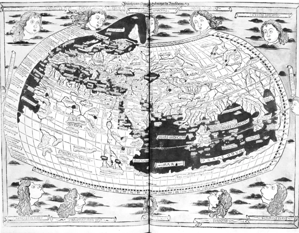
The history of maps as primary sources is as old as mapmaking itself. The earliest known maps, scratched onto cave walls or carved into bone, served practical needs: locating water, game, or shelter. As societies developed, maps became more systematic. The Babylonians created clay tablets with world maps, the Greeks and Romans produced sophisticated road maps and land surveys, and medieval European monks created elaborate mappae mundi that placed Jerusalem at the center of a Christian cosmos. The Age of Exploration in the 15th and 16th centuries transformed cartography, as navigators and royal cartographers raced to chart new coastlines and trade routes. By the 19th century, national surveys like the Ordnance Survey in Britain and the United States Geological Survey produced highly accurate maps, yet even these carried the assumptions of their makers—who owned land, what features were deemed worthy of recording, and which communities were invisible.
Historians use maps in two distinct ways: as primary sources and as secondary sources. When a teacher displays a 12th-century mappae mundi to illustrate the medieval worldview, the map is treated as a primary source—a text from the past that reveals how its makers understood the cosmos, religion, and geography. In the same classroom, a student might refer to a modern map to locate a historical site; that map is a secondary source, a tool created after the event. The distinction is crucial. As the American Historical Association notes, “historians use maps as both primary and secondary sources,” and the way they are used depends on the questions asked. A map can show where a battle took place, but it also reveals what the mapmaker considered important—perhaps the location of a nobleman’s estate but not the homes of peasants. The choice of what to include and what to omit is itself evidence.
How It Was Seen at the Time
Contemporaries who created and used maps understood them in ways that differ sharply from modern assumptions. For many centuries, maps were not meant to be neutral, scientific representations. They were instruments of power, devotion, and persuasion. A medieval mappae mundi, for instance, was not intended to guide a traveler; it was a moral and theological diagram, placing God’s plan at the center of the world. The mapmaker’s choices—what to include, what to exaggerate, what to leave blank—reflected the values and knowledge of their era. As the University of Nottingham’s research guide notes, maps and plans “act as repositories of information about a particular place or location at the time at which they were compiled.” They could record the names of landowners, the acreage of fields, even the state of cultivation. These details, often invisible in written records, offer a glimpse into the lives of ordinary people—not just the upper classes.
“No map can answer all the questions it raises.” — American Historical Association, 1995
This refrain underscores the humility that historians must adopt when working with maps. A map is not a transparent window onto the past; it is a constructed artifact, layered with meaning. The questions that mapmakers themselves would have asked—Who made this map? When and why? What choices did the mapmaker make?—are the same questions historians ask today. The map’s simplicity often masks a complex environment, covering many layers of meaning. A map of a parish from the early 19th century might show roads and rivers, but it might also show the names of tenants and the rental value of each plot, revealing social and economic structures that would otherwise be lost.
Historical Snapshot
| Aspect | Detail |
|---|---|
| Date | Maps have been made since prehistory; the earliest known maps date to around 25,000 BCE (cave paintings). The practice is universal across cultures. |
| Place | Every region of the world, from the Mediterranean to the Pacific islands, has its own mapmaking traditions. |
| People | Mapmakers include ancient Babylonian scribes, medieval monks, Renaissance navigators, and modern surveyors. |
| What Happened | Maps evolved from simple spatial records to complex instruments of navigation, administration, and propaganda. |
| Why It Mattered | Maps shape how we understand the past; they are primary sources that reveal the knowledge, biases, and priorities of their creators. |
What People Knew at the Time
| What People Knew Then | What We Know Now |
|---|---|
| Maps were often considered accurate, factual representations of the world. People trusted them as guides for travel and land ownership. | We recognize that maps are selective and subjective. They reflect the mapmaker’s choices, biases, and limitations, and can be used to control or mislead. |
| Medieval mappae mundi placed Jerusalem at the center and emphasized biblical places; they were not meant to be geographically precise. | We understand these maps as theological and ideological documents, not as navigational aids. They reveal the worldview of their makers. |
| Surveyors and cartographers in the 18th–19th centuries believed they were producing objective, scientific maps. | Modern historians analyze the social and political contexts of these maps, noting who was included or excluded, and how maps reinforced imperial or national narratives. |
| Maps were used to establish land ownership and boundaries, often without consulting the people who lived there. | We now recognize that maps can be instruments of erasure, ignoring indigenous territories or communal lands. |
Contemporary Terminology
To understand maps as primary sources, we must learn the language of their makers. The medieval mappae mundi (plural of mappa mundi) were world maps that depicted the known world, often with a theological orientation. The term cartography itself did not come into common use until the 19th century; earlier mapmakers were called cosmographers or geographers. The ordnance survey refers to the official mapping of Britain, begun in 1791, which produced detailed maps for military and administrative purposes. Cadastral maps showed land ownership and property boundaries, a crucial tool for taxation and administration. The projection is the method of representing the curved Earth on a flat surface; the Mercator projection, introduced in 1569, was designed for navigation but distorts the size of landmasses near the poles. Understanding these terms helps historians read maps with the eyes of their contemporaries.
How Historians See It Today
Modern historians approach maps as both a practical tool and a cultural artifact. The interpretation of maps has shifted from a purely utilitarian view—what is where?—to a critical analysis of power and knowledge. A map is no longer seen as an objective record; it is a constructed representation that reflects the political, social, and technological context of its creation. For example, a map of the Americas from the 16th century might show the coastlines but leave the interiors blank, labeled “terra incognita” (unknown land). This blankness was not ignorance but a deliberate choice, often reflecting the European perspective that only explored areas were worth mapping. Today, historians might also study the map’s projection, its decorative elements, and its marginal annotations to uncover the mapmaker’s worldview. The shift from seeing maps as “mirrors” to seeing them as “constructions” is a central theme in the history of cartography. As the Newberry Library notes, learning history is an ongoing process of making sense of evidence, and maps are one of the most valuable pieces of evidence because they preserve the spatial knowledge and assumptions of a past society.
Common Misconceptions
Related Primary Sources
- Medieval mappae mundi (e.g., the Hereford Mappa Mundi, c. 1300) are preserved in libraries and cathedrals; they show a Christian worldview with Jerusalem at the center.
- Portolan charts from the 13th–16th centuries, used by Mediterranean sailors, provide detailed coastlines and port names.
- Cadastral maps and surveys from the 18th–19th centuries, such as the Ordnance Survey maps of Britain, show land ownership and property boundaries.
- Colonial and imperial maps from the 19th century, including maps of Africa and Asia, reveal how European powers divided territories.
- Digital collections such as the Library of Congress Maps Collection, the David Rumsey Map Collection, and the Newberry Library’s Digital Collections offer high-resolution scans of historical maps.
FAQ
Why are maps considered primary sources?
Maps created in the past are primary sources because they provide direct evidence of how people at that time understood their world. They show the knowledge, biases, and choices of the mapmaker, making them invaluable to historians.
How do historians analyze a map as a primary source?
Historians ask questions such as: Who made this map? When and why? What choices did the mapmaker make? They also examine the map's content, its symbols, its omissions, and its context to interpret its meaning.



Leave a Reply